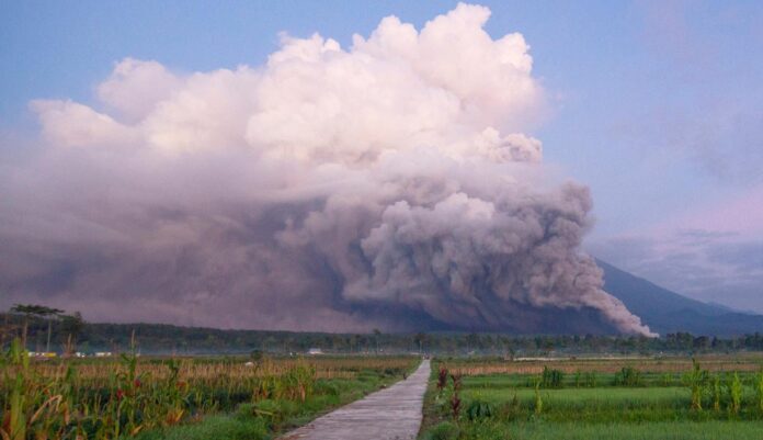
The highest mountain on Java Island, Mount Semeru, erupts. The eruption occurred on Sunday (4/12) morning. The status of Semeru has increased from Level III (Alert) to Level IV (Caution) since 4 December 2022 at 12.00 WIB.
As of Sunday (4/12) evening, the East Java BPBD noted that the number of refugees affected by the Semeru eruption was at least more than 2,219 people in Lumajang Regency.
The Ministry of Energy and Mineral Resources (ESDM) through the Geological Agency through the Center for Volcanology and Geological Hazard Mitigation until last night (4/12/2022) noted that the eruption of Mount Semeru was still ongoing, with no eruption column heights being observed.
The distribution of eruptive material in the form of ejected incandescent rocks is estimated to reach a radius of 8 KM from the summit, while the ash-sized ejected material currently reaches 12 Km to the southeast. The direction and distance of the distribution of this ash material can change depending on the direction and speed of the wind.
The direction of the hot clouds of avalanches and avalanches to the southeast and south sectors of the summit. The range of hot avalanches has reached more than 13 km.
“Cold lava and hot lava can occur along rivers that originate in peak areas, especially along rivers,” said the Geological Agency in a press release, Quoted Monday (5/11/2022).
Until now, Mount Semeru has been observed still launching hot clouds of avalanches (APG) with an amplitude of 25 mm and an earthquake duration of 386 seconds on Monday (5/12) morning.
Officer of the Semeru Volcano Observation Post (PPGA), Mukdas Sofian on Mount Sawur said that the highest volcanic activity on the island of Java during the observation period December 5 2022 at 00.00-06.00 WIB experienced one hot cloud avalanche with an amplitude of 25 mm and an earthquake duration of 386 seconds.
Semeru’s activity was also recorded for six earthquakes with an amplitude of 1-8 mm and an earthquake duration of 50-140 seconds, one deep volcanic earthquake, and one distant tectonic earthquake.
“Visual observations, Mount Semeru is clearly visible, observed white crater smoke with a thin to the moderate intensity that reaches 500 meters from the summit, then weak winds to the southwest,” said Mukdas.
The community is advised not to carry out any activities in the southeastern sector along Besuk Kobokan as far as 13 km from the peak (the eruption center).
Outside of this distance, the community does not carry out activities at a distance of 500 meters from the riverbank (river border) along Besuk Kobokan because it has the potential to be affected by the expansion of hot clouds and lava flows up to a distance of 17 km from the summit.
The community is also asked not to move within a 5 km radius of the crater/top of Mount Semeru because it is prone to the danger of throwing stones (incandescent).
Then be aware of the potential for hot cloud avalanches, lava avalanches, and lava along rivers/valleys that disgorge at the top of Mount Semeru, especially along Besuk Kobokan, Besuk Bang, Besuk Kembar, and Besuk Sat as well as the potential for lava in small rivers which are tributary of Besuk Kobokan.
In addition, the Lumajang Regency Government has set a disaster emergency response period due to an eruption accompanied by the APG of Mount Semeru for 14 days starting Sunday along with an increase in the status of the mountain which has an altitude of 3,676 meters above sea level to Caution or Level IV.


